


It’s only a matter of time before Cotopaxi erupts again; What’s been done to protect the public?
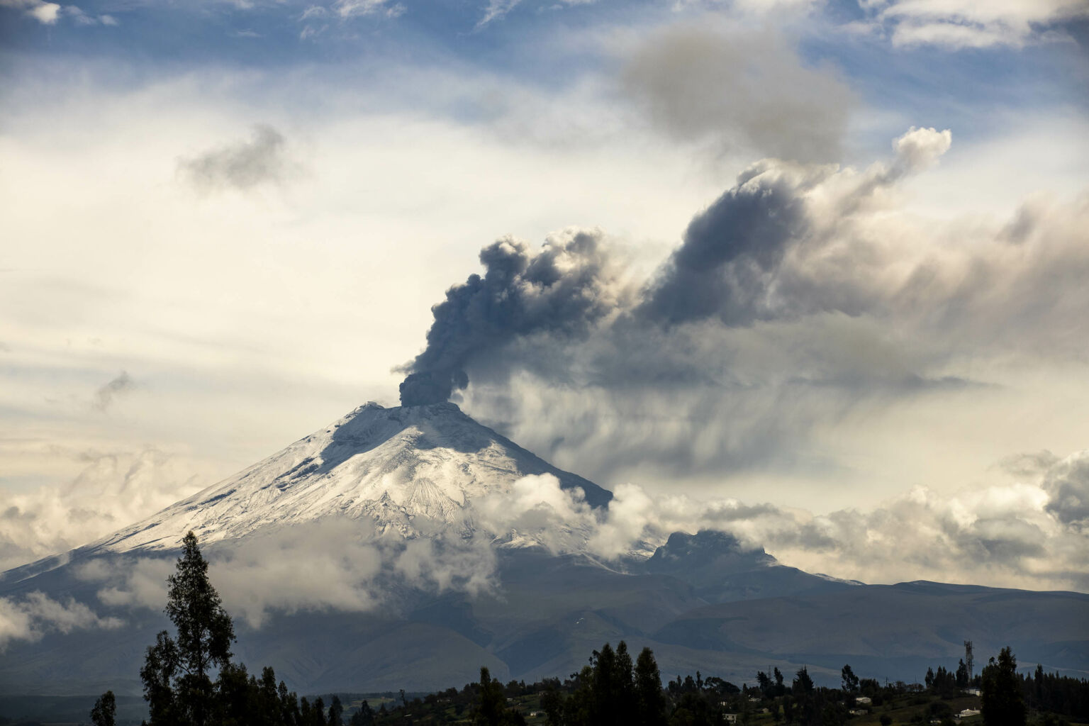
The Cotopaxi volcano during its small 2015 eruption.
By Barbara Espinosa
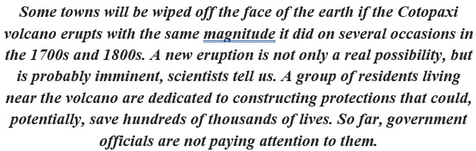
In 2015, the inhabitants of Ecuador’s Valley of the Volcanoes, south of Quito, were awakened by a thunderous explosion. A radio announcement explained what was happening and gave them a decisive order: “Lahars are coming down from Cotopaxi; they have 20 minutes to evacuate.” Cotopaxi is an active volcano that is close to 5,897 meters (19,347 feet) above sea level.
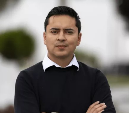
Edgar Yánez, Luis Guano Real and Iván Viera are three leaders and businessmen who live in the small community of Joseguango, one of the towns in the valley. Like most of its 4,000 inhabitants, Yánez, Guano Real and Viera make a living from broccoli, cows and roses. But on that early morning in 2015, the volcano whose name means “the neck of light” in the Kichwa language, put their lives and livelihood in danger of extinction.
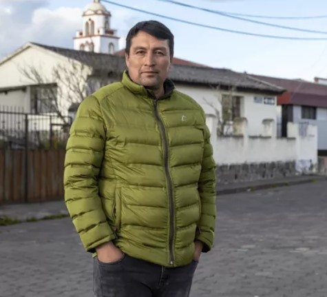
Edgar Yánez is a businessman who lives in one of the communities in the Valley of the Volcanoes. Photo by Armando Prado for GK
The soil of the Valley of the Volcanoes is fertile due to the thick layer of minerals left behind by past eruptions. Rivers flow down from the glaciers of Cotopaxi and, combined with groundwater sources they feed, provide abundant water to those who live here. The temperature is warm in the valley, compared to the cold winds on the volcano’s flanks.
Fertile soils, water availability, and bright sunlight contributed to the development of important agricultural industries in the area. The industries have contributed to the development of a multitude of cities and towns.
This story, however, focuses on four of those towns, which are situated close to the volcano: Latacunga, Joseguango, Mulaló and El Valle de los Chillos.
The city of Latacunga and the towns of Joseguango and Mulaló are located on the southside of Cotopaxi. El Valle de los Chillos, a part of urban Quito, is located to the north. They all seem to be wonderful places to settle down and start a life. Or at least they used to be. When Cotopaxi thundered in 2015, it did not eject pyroclastic material, lava, or rocks, but infinite lahars of panic. It was a small eruption.
In Latacunga and communities of Joseguango and Mulaló, people fled their homes when they heard the explosion. “They were crying and screaming. Some ran to higher ground. Others stayed at home, to save their belongings, to save their animals,” Yánez recalls. Hours later, they would discover that the eruption was small, nothing more than a rumble, that the lahars or mudflows expelled were small, and that they were never in any real danger. However, in the midst of the panic of the early morning, seven people died.
But for Yánez, Guano Real and Viera, that eruption was a warning sign. It was a red flag about how unprepared they were in the valley for a larger eruption. They know it’s coming. It will be big. They are worried about their future and of the people around them.

Iván Viera is a businessman and community leader from Joseguango, one of the towns in the valley that would be directly impacted by an eruption of Cotopaxi. Photo by Armando Prado for GK.
To prepare, they organize drills, first aid classes and awareness workshops. They paint and repaint evacuation route signs. But they also recognize that prior to 2015 there had been similar efforts, and they made little difference when the volcano roared. “Although people knew how to act, in the heat of the moment nothing mattered,” admits Guano Real. “People wanted to save as much of their belongings as possible. They wanted to save their children and their animals,” he recalls.
Shortly after the chaos of 2015, Yánez, Guano Real and Viera saw a change in the community. After realizing the danger that towered above them, “people did not have the peace of mind to invest and grow,” says Viera. “They began to sell their land and belongings at such low prices that it was almost like giving them away,” Yánez continues. “They also stopped being able to access loans from banks because their land was in a risk area and for the bank it was worthless,” says Guano Real.
But anguish and despair come in waves. “Over time, even the people who lived through the 2015 event forgot about it,” says Viera disheartened, recalling what for him and for the people of this valley was jsut the beginning of the Cotopaxi eruptive cycle.
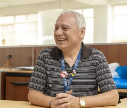
For Fernanda Naranjo, an engineer at the Geophysical Institute of the National Polytechnic School (IGEPN), the eruptive cycle of Cotopaxi is much more complicated.
The walls of the IGEPN are covered by screens that show trends and live broadcasts of each volcano in Ecuador. An entire area was designated to monitor Cotopaxi. “There’s always someone looking at these screens,” Naranjo explains. The Institute is tasked with monitoring seismic and volcanic activity in Ecuador to understand patterns that can help predict and advise about future threats. “But no one can completely predict when a volcano will erupt,” Naranjo says.
Monitoring of Cotopaxi began in 1976 and today, it is one of the best-monitored volcanoes in all of Latin America, explains Naranjo. The past data helps geologists observe patterns that indicate when volcanic activity rises to a level of concern.
Cotopaxi began to show signs of new activity in the early 2000s after more than 100 years of dormancy. Fifteen years later, came the great explosion that woke Yánez, Guano Real, Viera and all the inhabitants of the valley. It was a release of ash and gases. By 2024, activity has dropped, but not to pre-2000s levels. We know this in large part thanks to the monitoring of Cotopaxi, but that is not the only tool used to study volcanoes.
An understanding geological patterns also comes from oral indigenous history. Cotopaxi, in fact, is a mythological presence of the Kichwa communities of the sierra. Legend has it that the volcano, in love with Princess Quilotoa, fought another volcano, Chimborazo, for his love, but its fury caused Quilotoa to plunge into its lagoon, leaving him sad and lonely. The one who was seen as a protective guardian of Andean communities, whose eruptions symbolize their fight against the forces of evil, is for 21st century inhabitants of the Valley of the Volcanoes, a source of danger.
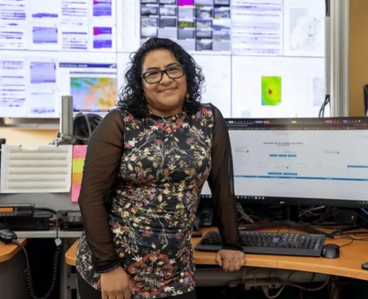
Fernanda Naranjo is an engineer at the Geophysical Institute of the National Polytechnic School (IGEPN) and talks about the complexity of the volcano’s eruptive cycle. Photo by Armando Prado for GK.
For this reason, resorting to the local indigenous tradition allows us to understand it – no longer on a mythical level, but on a geological level. “There is an old indigenous saying: When the Guagua Pichincha cries, the Tungurahua mother shudders and the Cotopaxi taita gets angry,” says Naranjo. The Guagua Pichincha is a small volcano right next to Pichincha next to Quito. It gets its name because of its small size: ‘guagua’ in Kichwa means baby.
The last eruption of Guagua Pichincha was in 1998 and covered Quito with ash. Shortly after, the eruptive process of the Tungurahua volcano began. Now, it’s Cotopaxi’s turn. “What has happened before will happen again,” explains Naranjo, recalling that this is one of the principles of geology.
The geological patterns echo the indigenous saying: the eruptive cycles of Cotopaxi have been characterized by leading to a major eruption. This large eruption has occurred five times in recorded history. It has not yet happened in the current eruptive cycle but is overdue, Naranjo says.
This large eruption will bring “three or four days of darkness,” says Naranjo, referring to the description of the 1877 eruption in the book Las Crónicas de Sodiro, written by the Jesuit Luis Sodiro.
The darkness is caused by a rain of ash that, Naranjo explains, that kills plants and farm animals, causing hunger and economic stagnation for the human population. These conditions occur not only in the area near the volcano, but throughout most of Ecuador. As scary as description sounds, it is not the worst of it. The main concern is lahars, says Oswaldo Padilla, a geographic engineer at the ESPE Armed Forces University.
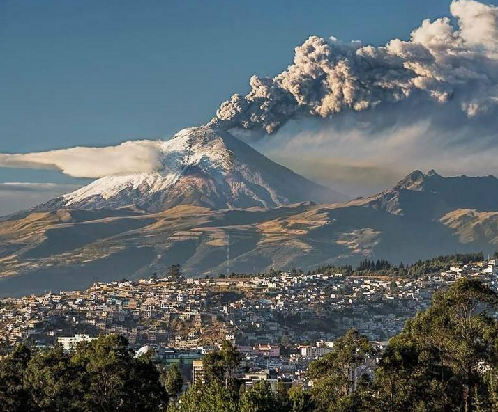
The Cotopaxi volcano in 2015 as seen from southern Quito.
In thirty years of work, Padilla and his team have developed multiple hyperrealistic computer models to map the flow of lahars from Ecuadorian volcanoes.
Lahars form during an eruption when hot gases melt glaciers and create giant rivers of mud and rock that destroy everything in their path. They slide down the mountain at high speeds, leaving a trail of destruction in their wake, Padilla says. When Cotopaxi explodes — “and we are close to that possible event” — the lahars will reach the towns located along the rivers that flow from the volcano’s glaciers. Included in those town are Latacunga, Joseguango, Mulaló and El Valle de los Chillos, according to Padilla.
“If we have a magnitude 4 eruption, we will have three flanks of lahars,” Padilla explains, as he displays the model on his computer. “One will go to the east of the volcano,” to a mostly uninhabited area bordering the Amazon region. “One will go north,” towards El Valle de los Chillos. And “one will go south,” to Mulaló, Joseguango and Latacunga. “The south is much more vulnerable to the lahars,” Padilla says. Four streams born in Cotopaxi’s glacier run to the south. In addition, the volume of lahar material headed south is three times that headed north.
The models confirm the fears of Joseguango residents Yánez, Real and Viera. “Mulaló is the town with the highest risk, because it is so close to the volcano. But Joseguango is not far behind. In the event of an eruption, 40% of Joseguango will be erased from the map,” says Yánez.
Padilla explains that the models he and his team created are coded using the worst-case scenarios. They expect the eruption to be smaller, but they model for the worst. They even increase the magnitude of the eruption by 10% to account for the additional uncertainty.
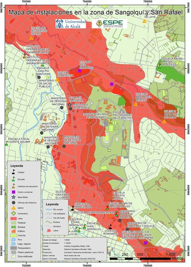
Map showing lahar and lava flow from a major eruption of Cotopaxi into the towns of Sangolqui and San Rafael in the Los Chillos Valley, east of Quito.
They are also working to make the models accessible online and available for anyone who is interested. “You can even access the model and say: I live here, what’s going to happen there? It is not exact. Nature has a mind of her own, but at least you can see if the area where you live will be affected,” Padilla explains. Despite his and his team’s work, Padilla believes the Valley of the Volcanoes and its towns are nowhere near being prepared for a big eruption.
Xavier Haro, a civil engineer and resident of Latacunga, agrees. “Unfortunately, Latacunga does not have enough action plans, awareness, and drills to withstand an eruption of Cotopaxi,” he says, discouraged by the way politicians handled the 2015 explosion.
Haro, who works as a contractor and civil engineer, explained that his field of work is now much more difficult to navigate. “In 2015, the construction business collapsed. Cotopaxi really had a negative effect on the way I made a living,” he says. He points out that his house is next to the Cutuchi River, so he is at highest level of risk. “The government did nothing for us,” Haro said. “No planning, no follow-up, they said we were on our own to face what comes.”
***
Although the eruption and consequent lahars are inevitable, the destruction of houses such as Haro’s in Latacunga, and Mulaló’s in Los Chillos, can be prevented. There is a solution to prevent Cotopaxi lahars from reaching communities: the construction of mitigation barriers.
When I asked Haro about it, he told me that because of its high cost, he does not believe that the government will fund the necessary infrastructure work. But if it is built, he would like to be part of the planning and construction team. Theofilos Toulkeridis, geologist, geochemist, paleontologist and risk management expert at the ESPE Armed Forces University, explains that without barriers, the losses will be indescribable and will greatly exceed the cost of building them. “Bridges, hospitals, housing. These are some of the infrastructures that will be lost. Also, hydroelectric power plants in the area. The prison, too,” Toulkeridis says.
The Cotopaxi prison, on the outskirts of Latacunga, is one of the largest in Ecuador and currently houses more than 4,000 men and women. If Cotopaxi erupts and there is no mitigation structure, all those people will be at risk and will die if there is not enough time to move them.
Xavier Haro is a civil engineer and resident of Latacunga and believes that the canton does not have enough plans to withstand an eruption of the Cotopaxi volcano. Photo by Armando Prado for GK.
“There are many other people and structures at risk, of course,” says Toulkeridis, as he plays a video based on descriptions from The Sodiro Chronicles showing what will happen when Cotopaxi explodes. The images are of floods, destruction of homes, and injuries and public panic.
The threat from Cotopaxi hits close to home for Toulkeridis since he lives in Los Chillos. He has been studying the Cotopaxi volcano since he moved to Ecuador from Greece in 1998. Since his arrival, he has directed multiple studies of the iconic volcano, publishing his results. “We have so much science that we can answer questions you haven’t even thought of yet,” he jokes.
I ask him if mitigation works would be a better solution than resettlement. “Resettlement would be too costly,” he replies. “We can implement alarms, evacuation and monitoring plans, and expect them to work,” he says. “But, in the end, the only option that allows people to stay safe and keep their homes is to build the mitigation barriers,” he says. It will not be cheap, he says, but it will be much cheaper than resettlement or destruction.
Building the barriers would cost $130 million on the north side of the volcano and $400 million on the south, Toulkeridis says. “And to understand how this infrastructure works, you first need to understand the morphology of a lahar,” he says. He describes a lahar as a large worm, with a large head made of giant rocks the size of houses, and a body made of mud. “The most worrying thing is the head, the rocks, and that’s what we need to stop,” he says.
The solution is simple: build holes or ditches that catch rocks before they reach cities. “The construction of this infrastructure will not only protect the towns but will also create jobs for the community and the material that is extracted can be sold and used for construction,” he explains, finding economic circularity in the prevention of a tragedy.
Theofilos Toulkeridis is a geologist, geochemist, paleontologist and risk management expert at the ESPE Armed Forces University. He says that without mitigation works, the losses will be very high. Photo by Armando Prado for GK.
Although these holes may not be able to trap all of the rocks, additional forms of mitigation infrastructure can be added that break up the rocks, reducing their size and the damage they cause. “This is called ‘Giant Step’s and it has been done in Japan,” Toulkeridis explains. You can also mitigate the impact of the lahar by building giant strainers that separate the rocks from the mud.
“There are options and we have time,” he says.
These are existing solutions that have already been applied successfully elsewhere. “But if we don’t do anything, we could face a human tragedy, maybe a hundred thousand deaths,” Toulkeridis says. Saving one life should be enough to build this infrastructure, but saving so many more, should make these works a top priority for local and national authorities.
***
“Andor he was living in Latacunga in 2015 when the emergency for Cotopaxi occurred,” says Freddy Játiva, a former Army colonel and civil engineer who led the Army Corps of Engineers and who was also director of the ESPE at its headquarters in Latacunga.
“When you live in Latacunga, problems with Cotopaxi become a daily occurrence. Friends and family shared their concerns,” he tells me, sitting in the livingroom of his house. “A friend shared with me the mitigation infrastructure proposed by Toulkeridis, and I thought it was very interesting and very doable. When you have a flow of water and the slope is very steep, you can add heatsinks to interrupt and slow down the flow. It is a simple principle,” explains Játiva.
“Theoretically it is very feasible. And logistically it’s also very feasible,” in part due to the mining nature of Mulaló, Játiva says.
Mulaló is a mining town. People dig giant holes on the outskirts of Mulaló to extract construction material. “Some of these holes are already in the path of the lahar and with additional reinforcements, they will substantially reduce the damage. Part of the work has already been done,” says Játiva.
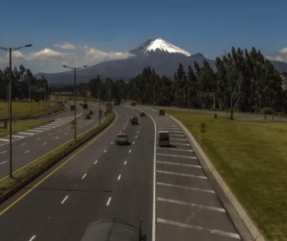
On the road to enter the city of Latacunga you can see the Cotopaxi volcano. Photograph by Armando Prado for GK.
He recalls that, when he was stationed in the Ecuadorian Amazon, he and his team confiscated 148 backhoes from illegal mining. “They are not currently being used and could be used for the construction of mitigation works,” he says. The considerations highlighted by Játiva would substantially reduce the cost that Toulkeridis calculated.
I ask him what happened. “We had conversations with political authorities, we discussed that this would happen and they listened. And then, when the microphone was off, they would tell each other that this would not happen. There was no political support. Currently, the plan is that if there is an eruption, people in the valley will simply have to evacuate during the Orange Alert,” he says.
The Orange Alert means that eruptive activity is high. Orange is the alert just before the Red, which means that the volcano is actively erupting. “The idea is that if people evacuate during the Orange Alert, no lives will be lost. But that’s like not fixing the brakes on your car and just hoping you don’t have to make a fast stop,” says Játiva.
***
Tania Vásquez was the governor of the province of Cotopaxi until 2023, and is one of the political authorities who listened to the citizens of Latacunga when they asked for mitigation infrastructure.
“I had the opportunity to tour the volcano with citizens concerned about their safety and with experts in risk management. I was able to do so thanks to the will and concern of the people of the province of Cotopaxi. Later, their willingness and concern resulted in a meeting with a Japanese organization that would invest in the mitigation works,” explains Vásquez. “But then we discovered that this was not a priority for the national government,” he says.
The president was more concerned with fighting crime, he says. In recent years, Ecuador went from being one of the most peaceful countries in Latin America to one of the most dangerous: in 2017, the homicide rate was 5.8 per 100,000 inhabitants, just six years later this figure has quadrupled. “For mitigation works to happen, we would need a policy and a budget from the national government, which would need to prioritize this,” he says. “So far, the political will does not exist.”
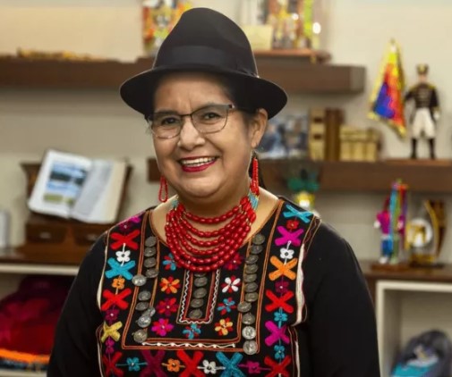
Since 2023, Lourdes Tibán has been the prefect of the province of Cotopaxi. Among their concerns is the lack of resources for plans to deal with a possible eruption of the volcano. Photograph by Armando Prado for GK.
The new prefect of Cotopaxi Province, Lourdes Tibán, has not been involved in the development of the mitigation works. She will, she says, “when there is money to make this a reality”.
The prefect is the highest provincial authority elected by the voters, while the governor is the highest representative of the president in a province. Neither of them seems to have the financial muscle to build the works that could prevent thousands of deaths.
Tibán, a well-known indigenous activist, politician and lawyer, has been busy addressing other issues that will arise when Cotopaxi explodes. “We have been working to find water sources for the province that have nothing to do with Cotopaxi,” he says. “We know that when Cotopaxi explodes, people whose drinking water depends on Cotopaxi will run out of water. We have also been improving roads and paths to facilitate evacuation. In addition, we are also building shelters,” she explains.
Despite all this, Tibán does not believe we are prepared to face an eruption of Cotopaxi. She says the national government is the entity in charge of financing and developing mitigation works and should be begin the project as soon as possible.
She is also convinced that for this to happen, the citizens of Latacunga, Cotopaxi, Mulaló, El Valle de los Chillos and all the others who would be affected by the disaster must demand that this happen. “People need to get organized! People must raise their voices not only when disaster knocks on our door, but before, while we still have time,” Tibán demands. Being reactive is perhaps one of the great evils of our country.
****
Luis Chasi Chacón is a founding member of a collective action group called CALU, which stands for Active Cotopaxi, Latacunga Unida, which has existed since 2022. “That year we realized that there were many discrepancies between the information provided by the IGEPN and by the Risk Management Secretariat,” he says. CALU’s primary objective is to advocate for the development of mitigation works.
Chasi was part of the group of citizens who held talks with Vásquez, the former governor of the province of Cotopaxi. He explains that when these conversations took place he thought they were close to achieving something. “Now I’ve lost hope,” he admits. “They forgot about us. They forgot about the Cotopaxi volcano. They forgot that every time Cotopaxi begins an eruptive process, it ends with a highly destructive eruption.” He still believes that with enough pressure from the community something could happen.
But he also feels desperate. I used to live in the risk zone. Not anymore. He built a new house, in a safer place. He recognizes that most people don’t have that privilege.
Until April 2024, Cotopaxi’s activity levels remain stable, but it has not decreased to the pre 2015 level. The large eruption has not yet occurred, but experts say it will. The mitigation works have not been built and those who live in risk areas continue to “sleep peacefully surrounded by roaring volcanoes,” as Alexander von Humboldt said more than 200 years ago following his visit to Ecuador.
As I look at the volcano, massive and powerful, I think about how current Humboldt’s stupefaction is: how can the thousands of inhabitants of the Valley of the Volcanoes “sleep peacefully”? But above all, I wonder how those in power can sleep, knowing that there is a colossal threat to hundreds of thousands of people — and a feasible solution if the government elects to pursue it.
__________________
This article was produced in collaboration with the Pulitzer Center.
Barbara Espinosa Barrera, is a recent master of public health graduate of Boston University and former Public Health Post Fellow at the university. For her journalistic work, she was named a 2023 Pulitzer Center Reporting Fellow. She plans to return to home and Ecuador to continue a care in public health and journalism.
The article appeared originally in Spanish on the GK website.