


Indigenous governance is the key to protecting Amazon Basin connectivity, experts say
By Constance Malleret
In the southern tip of Colombia’s Cauca department, known as the “boot” for its shoe-like shape, volunteer members of an Indigenous guard patrol their territories in the Andean foothills to protect them from invasion and deforestation. The municipality of Piamonte, which covers most of the boot, suffered the highest loss of forest cover in Cauca between 2001 and 2024, according to data from Global Forest Watch.
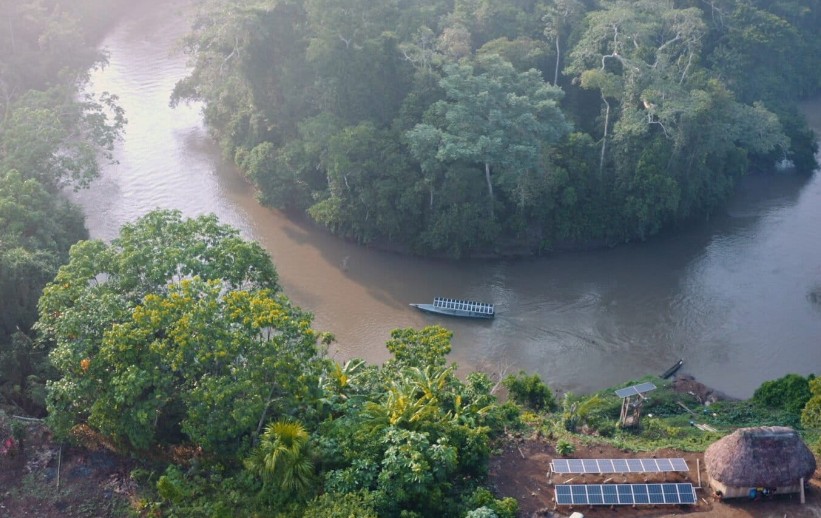
The Kapawi River in the Amazon is a lifeline for more than 1,000 Indigenous peoples and is home to endangered pink river dolphins (Inia geoffrensis). Image by Andrés Cornejo.
“There are two fronts: illegal mining by illegal armed groups, and legal mining” by companies with permits, said Edinson Ramos Usnas, a member of the Nasa people and the coordinator of Cauca’s regional guard. “Mining cuts down trees, it destroys the land, it creates pits. This is causing many species, including native tree species, to disappear,” said Gloria Rivera, a Nasa woman from Cauca.
This degradation of the forest where the Andes meet the Amazon, a biodiversity hotspot, has impacts that go beyond its immediate surroundings, according to a report by the Science Panel for the Amazon (SPA) looking at landscape connectivity in the Amazon Basin.
Ecological connectivity between the rivers, lowlands, wetlands and Andean foothills in the Amazon is essential to guarantee the survival of the rainforest and the ecosystem services it provides. Anthropogenic activities are threatening landscape integrity and therefore connectivity, the research shows, while Indigenous territories and conservation areas are the best barrier against deforestation. This means that supporting Indigenous governance and the integrity of these territories at a transnational level is vital to protect the Amazon as a whole.
“The results are super clear. The zones which have governance of protected areas and Indigenous territories have greater connectivity than other zones,” said Juan Manuel Guayasamín, a biologist who contributed to the paper and is a professor at the Universidad San Francisco de Quito in Ecuador.

Where the Andes meets the Amazon in Ecuador. Photo credit: Rhett A. Butler / Mongabay.
The Andean foothills of Colombia, Ecuador and Peru, along with the lowland forests along the Amazon River in eastern Brazil and the so-called “arc of deforestation,” which reaches from Brazil’s Pará state in the east to Bolivia in the west, are the areas in the Amazon Basin that have suffered the greatest loss of connectivity according to the SPA’s paper, which is based on a 2025 article published in Proceedings of the National Academy of Sciences.
Researchers found that at least one anthropogenic activity — whether mining, dams, oil and gas exploitation, roads or deforestation, which is linked to all the above — affected 23% of the lowlands, 24% of the rivers, 25% of the wetlands and 28% of the Amazonian Andes. Meanwhile, Indigenous territories cover around 29% of the Amazon River Basin and protected areas, 23%. Ecosystem disruption is lower in Indigenous territories and protected areas, at 14% and 16%, respectively, compared with 38% in other areas.
“This is not a novelty, but we show once again, in yet a different way, that the quickest, most effective and most socioenvironmentally fair solution [for conservation] is the demarcation of Indigenous territories and the creation of protected units, principally those that maintain traditional populations involved,” said Camila Duarte Ritter, co-author of the study and a researcher at the Juruá Institute in Brazil.
The Andes-Amazon connection
A critical connection being lost is that provided by rivers, which are born in the Andes and flow through the Amazon lowlands before reaching the Atlantic Ocean, a vital link between the high-altitude Andes and the rainforest.
These rivers carry nutrients that feed the different ecosystems and play a role in countless processes, from the flood pulse in the wetlands and wildlife reproduction to the formation of the flying rivers that carry rain to other parts of South America, according to Ritter.
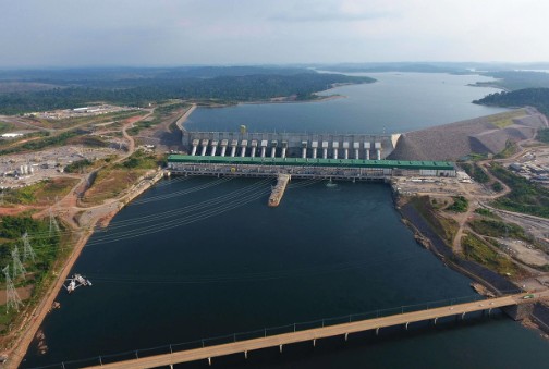
The Belo Monte complex has diverted 80% of the Xingu River’s water flow, affecting one of the most important rivers in the Amazon and the livelihood of the communities who depend on it. Image courtesy of Norte Energia.
“All the ecosystems depend on each other,” Ritter told Mongabay in a video interview. “When a hydroelectric dam is built in the middle of a river, it interrupts these processes.” Mining also heavily impacts riverine ecosystems, the paper notes.
The data set used by the researchers recorded 347 dams in operation in the Amazon Basin as of 2023, 85 dams under construction and a further 397 in planning stages.
“We have very few rivers that still serve as connectors between the Andes and the Amazon,” Guayasamín said.
To help preserve this threatened riverine connectivity, the researchers recommend ending in-stream mining in all Amazon waterways and creating dam-free sanctuaries on and around rivers that have not yet been interrupted, notably the Putumayo-Içá on the Peruvian-Colombian border, the Beni and Madre de Dios, which flow through Bolivia, and the Japurá River in Brazil.
Even these face pressure, however. Ramos, of the Cauca Indigenous guard, said “there is a latent threat” of hydro projects in Cauca, where the Caquetá River, which becomes the Japurá in Brazil, has its source.
“The worldview of Indigenous peoples determines that rivers and watersheds remain exactly as they are, established by nature and the wisdom of the forest. Any intervention would cause immense disruption, affecting not only the territory but also the lives of Indigenous peoples,” Ramos said.
Other recommendations include the creation of three biodiversity reserves connecting conservation units and Indigenous territories in better-preserved parts of the rainforest. A northern/Colombian corridor would run from the Serranía de los Churumbelos National Park in southwest Colombia all the way to the Yanomami Indigenous Territory in northern Brazil; a southern corridor would include the south of Peru’s Amazon and Amazonian Andes, to the Vale do Javari Indigenous Territory in western Brazil; and a corridor in Ecuador would connect the Cayambe-Coca, Sumaco and Yasuní national parks, which already suffer interference from oil exploration.
Additionally, restoration efforts must go hand in hand with the creation and protection of Indigenous territories and parks, the researchers note.
A need for transnational collaboration
As the Amazon covers nine countries — although the definition of the Amazon Basin used in the paper does not include French Guiana, Guyana and much of Suriname — effective conservation requires international coordination.
“A disruption in one area is not going to be local; it will affect the whole basin,” Ritter said.
She and Guayasamín suggest the creation of an independent transnational committee to uphold minimum agreements on conservation.
“We could have a committee with government representation, but also [representation] from Indigenous peoples, academia, local actors … a committee that would be in control of monitoring and could truly demand of countries that they meet certain agreements,” Guayasamín said, while adding that this is “wishful thinking” in the current political climate.
And while international coordination would be the ideal scenario, he noted that even a patchwork of different forms of protection is successful in preventing deforestation, as shown by the research — although there is a need for stronger application of the law.
Strengthening Indigenous governance
“Local and bottom-up organizing seems to offer more possibilities for truly creating solutions,” Guayasamín said.
Ritter works in two regions of the Brazilian Amazon with contrasting realities. The Médio Juruá is “one of the most conserved areas of the Amazon” where community engagement has helped create extractive reserves, a type of protected areas where traditional communities can make a living from the forest and locals successfully defend their land from illegal activity. Meanwhile, the Volta Grande do Xingu is the site of the massive Belo Monte hydroelectric plant, which has left Indigenous and riverine communities displaced and disconnected while causing severe ecological damage.
Near Brazil’s border with Bolivia, at the other end of the arc of deforestation, the Kaxarari Indigenous Territory similarly lives under the shadow of the Jurau hydroelectric dam on the Madeira River. Built downstream from the Kaxarari land in the late 2000s, the dam has caused floods and diminished fish populations, upsetting fishing practices.
The Kaxarari also suffer from threats of invasion from illegal loggers and the effects of a changing climate, with prolonged droughts and the disappearance of certain animal species, Mauricélio Kaxarari, a local youth and Indigenous leader, told Mongabay over the phone.
He sees community organization as a necessity to better protect the territory and would like to receive support in developing the tools to do this.
“We haven’t had any training here, for example, for our relatives to do work like firefighting or territorial monitoring,” Kaxarari said. “Another aspect from which we suffer is the question of strengthening our internal organizations and associations,” he added.
Strengthening Indigenous territorial governance, as the Kaxarari are demanding, is key to the protection of these territories, Ritter said, and thus to preserving the connectivity of the Amazon Basin.
“We have enough knowledge, enough data, enough efficient examples to act. There is no excuse,” she said.
_________________
Credit: Mongabay