













El Niño is already breaking records on the coast and the worst is yet to come
Although the worst is still months away, Ecuador is already experiencing strong effects of the approaching El Niño. “The daily temperatures on the coast are higher than we have ever seen for this time of year and confirm the predictions that this will be the strongest El Niño on record,” says Vladimir Arreaga of the National Institute of Meteorology and Hydrology (Inamhi).
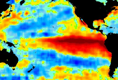
Ecuador is “ground zero” for the developing El El Niño.
July and August are typically the coolest months on Ecuador’s Pacific coast due to the strong flow of the Humboldt Current, which brings cold water up from Antarctica, Arreaga says. “Under normal conditions, the current not only cools the water but brings northerly winds,” he says. “Because of El Niño, the pattern has changed this year.”
In Guayaquil, July high temperatures normally reach 29°C or 30°C degrees. This year, maximum temperatures reached 33°C on several occasions. In Santa Rosa, in El Oro Province, temperatures are even warmer, averaging four degrees higher. “Across the entire coastal region, temperatures are at least three degrees above normal and several locations average 4.5 degrees higher,” Arreaga said.
He added that higher temperatures are also being recorded in the Andes and Amazon regions of the country. “Quito and Cuenca are about 1.5 degrees above normal for July and August.”
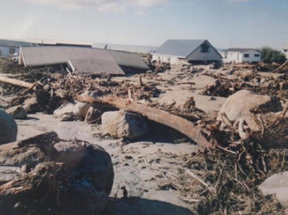
Many coastal areas of Ecuador were devastated by the 1997-1998 El Niño.
According to Bolívar Erazo, a hydrology and climate specialist and former Inamhi forecaster, “we are very early” in the El Niño cycle. “The fact that the water and inland temperatures are the highest ever recorded is frightening,” he said. “Ecuador is ground zero for all El Niños so we expect to feel the impact first, but what we are currently experiencing is beyond anything we have seen before.”
Besides the record temperatures in Guayaquil, Santa Rosa and Portoviejo, the ocean temperature is at a record high. “Even in June, fishermen were traveling 30 or 40 kilometers further to sea because the fish had relocated to deeper, cooler water,” Erazo said. “Now fishermen are going as much as 70 kilometers offshore and this has never happened before.”
As of August 22, Pacific Ocean water temperatures near the coast were at a record 3.5C degrees above normal. “The prediction is for rains to start in late October or early November, but they could start sooner because of the strength of the system.”
Although flooding causes the most damage in El Niños, Erazo says he is equally concerned about drought in the mountains. “We are already seeing drought conditions in the Andes, especially in the central and southern inter-mountain valley,” he says. “This is the area that produces two-thirds of the country’s hydro-generated electricity and we all remember the blackouts during the 2023-2024 El Niño, which was a relatively mild event. I am extremely worried that this drought will be worse.”
Erazo and Arreaga both expect the same impact pattern from previous El Niños. “There will intense rainfall and flooding at elevations under 1,500 or 1,600 meters and drought at higher elevations,” Arreaga says. “The coast will experience the most damage. The rains will probably start in October and continue every day until March or even April of 2027.”
Like Erazo, Arreaga worries that the drought in the inter-mountain valley could be more intense than the 2024 drought. “All any of us can do is prepare for the worst and hope for the best.”