












Historically high sea water temperatures are fueling the early arrival of El Niño storms
“This is something we have not seen before,” says meteorologist Bolívar Erazo, referring to the high temperatures of Pacific Ocean waters off the coast of Ecuador and Peru. “We knew this would be a strong El Niño but its strength is off the charts in comparison to previous El Niños and it continues to get stronger.”
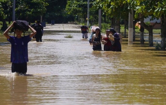
Students waded through knee-deep water to attend classes last week in Guayas Province.
The high water temperatures explain the early arrival of heavy rains in the country’s coastal region,” Erazo says. “With previous El Niño systems, including 1997-1998, the rains began in November and continued into the following year, but because of the strength of this system we cannot rely on previous patterns for making predictions.”
On Sunday, water temperatures off the coast measured 28 and 29 degrees centigrade, six or seven degrees above the seasonal average and, more alarming, Erazo says, two to three degrees above those of the devastating 1997-1998 El Niño. “The temperatures are still rising whereas they peeked in late August in 1997-1998.”
Rina Gabriel Valverde, oceanographer for Peru’s National Study of the El Niño Phenomenon (Enfen), says the temperature rise since mid-September is “unprecedented” and is setting new records. “We are witnessing anomalies of a magnitude we have not experienced before, which is extraordinary and also frightening,” she says.
Like Erazo, Valverde is “stunned” that sea water temperatures continue to rise. “Based on previous events, they should have reached the maximum two months ago.”
“Thie high temperatures explain why we are already having heavy rains in northern Peru, in Tumbes and Piura,” she added. “We had predicted that El Niño rains would begin in late October or November.” What is especially concerning, Valverde says, is that we are only in the early stages of this. “The rains and floods will continue for months and there will be little relief for residents of the coastal and littoral regions of Peru and Ecuador.”
A dangerous side effect of the high temperatures is sea level rise, says Erazo, former director of Ecuador’s National Institute of Meteorology and Hydrology (Inamhi). “The ocean level has risen 40 centimeters above normal due to the warming and when strong storms move in from the Pacific, especially at high tide, this pushes water inland and intensifies the flooding.” He added: “We have already seen this in Esmeraldas Province.”
Erazo is reluctant to offer a long-range forecast for El Niño. “One thing we have learned through experience is that each El Niño behaves differently and despite the intensity of this system I don’t want to compare it to previous systems, such as 1998,” he said.
“One thing that is almost certain is that the coastal region of the country will endure terrible flooding in the coming months,” he says. “This is already happening. There is a strong correlation between high water temperature and the moisture and rainfall it produces.”
Predicting El Niño’s impact in the sierra and Amazon is more complicated, Erazo says. “It is typical that the sierra and inter-mountain valley experience dry weather during El Niños but there have been exceptions,” he says. “My friends are asking if the reservoirs will go dry and if we will have blackouts again and I tell them I don’t know. Yes, it is very likely there will be drought in the valley, especially in the Austro region where most of the hydroelectric plants are located.”
He adds: “My biggest concern is that there could be a prolonged drought, going far into 2027 and that we will miss the rainy season.”