


Looking back at Ecuador’s most destructive earthquakes; What areas are at the greatest risk?
By Liam Higgins
The last week serves as a reminder that Ecuador is one of the world’s most seismically active regions. In the last six days, the country has experienced strong earthquakes of 6.1, 5.3, 4.8 and 4.5 magnitude, the first two being felt in Cuenca and most of southern Ecuador.

A small boy walks through the rubble of the 1949 Ambato earthquake.
According to Ecuador’s Geophysical Institute, the country has registered 4,127 seismic events of 3.5 magnitude or greater since 2013, the largest being the 7.8 magnitude April 16, 2016 quake centered in Manabí Province. That event left 670 dead and 6,275 injured and billions of dollars in damage in four coastal provinces.
The most recent deadly earthquake occurred on March 18, 2023, centered on Puna Island, south of Guayaquil. It resulted in 13 deaths, including one in in Cuenca, and destroyed more than 100 structures in a three-province area. A 5.8 magnitude aftershock, also centered on Puna Island, was recorded early Tuesday morning.
Besides the 2016 earthquake, what are Ecuador’s most destructive earthquakes in recorded history?
Geologists agree the largest since the arrival of the Spanish in the 1530s occurred in 1906, centered in the Pacific Ocean, just offshore of Esmeraldas Province. With a magnitude estimated between 8.8 and 9.0, the quake reportedly killed 1,500 in the Esmeraldas, Río Verde, Limones, La Tola and Tumaco-Colombia area.

Earthquake damage near Manta in 2016.
As many as 200 more deaths were reported in Hawaii and Japan due to the tsunami generated by the earthquake. In Hawaii, waves of 15 meters (45 feet) were reported.
According to the Geophysical Institute, Ecuador’s strongest on-land earthquake, estimated at 8.3 to 8.5 magnitude, struck near Antigua Riobamba on February 4, 1797. According to records, more than 12,000 died and Riobamba and other Spanish settlements within a range of 80 kilometers were reduced to rubble. As a result, the city of Riobamba relocated to a site 15 kilometers to the east.
According to Spanish records, the earthquake was felt strongly throughout Ecuador and into what is today southern Colombia. Buildings were destroyed not only in Chimborazo but in Pichincha, Tungurahua, Cotopaxi and Bolívar Provinces. Strong aftershocks continued for four months after the original earthquake.
On August 16, 1868, a 7.3 magnitude earthquake struck near Ibarra, north of Quito, killing 5,000 of the 7,500 who lived in the city and surrounding area. The quake destroyed several towns in Imbabura, Carchi and Pichincha Provinces. It also destroyed all roads connecting Quito and Ibarra, many of which were not restored for 20 years.
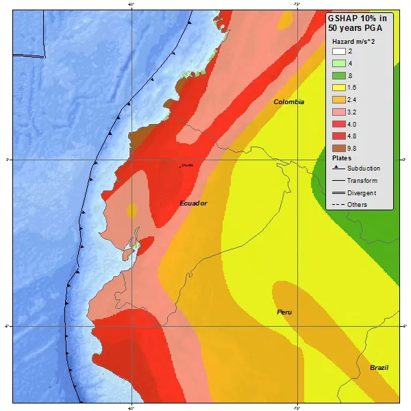
An earthquake risk map compiled by Ecuador’s Geophysical Institute. Areas shown in brown and red are at highest risk.
Ecuador’s most deadly 20th century earthquake leveled most of Ambato on August 5, 1949. Measured at 6.9 magnitude, the earthquake killed more than 6,000 and left 100,000 people homeless. The quake was felt throughout the country and caused minor damage in Quito and Cuenca.
Because of the devastation, the city of Pelileo, southeast of Ambato, was rebuilt on another site 8 kilometers away.
Besides the Ambato and 2016 Manabí earthquake, an earthquake measuring 7.2 magnitude struck Bahía de Caráquez, also in Manabí Province, on August 4, 1998. Although only five deaths were reported, property damage was estimated at two billion dollars. The quake was felt strongly in Quito and Guayaquil where some damage was reported.
With the exception of Cuenca, all major Ecuadorian cities have experienced earthquakes of greater than 6.0 magnitude since the arrival of the Spanish. Most of the historic structures in Quito have been rebuilt following earthquakes, some of them more than once.
In its earthquake risk maps, the Geophysical Institute shows the Pacific coast of Ecuador to be the most vulnerable to large earthquakes due to the collision of tectonic plates offshore. The second most earthquake prone zone is in the Andes, beginning just south of Riobamba and continuing northward to the Colombian border.


")