Solo crossing the Cajas
Author’s Note: In July and August of 2018, the City of Cuenca, Ecuador presented my solo exposition “Momento Decisivo – Joyas Ocultas de los Andes.” Nine selections of my art hung in the Museo Central de la Escuela Viejo in El Centro. The exposition was originally intended to be mostly my portrait work. However, Cuenca City felt that some of the landscape work I had produced was reminiscent of well known landscape works by famous Ecuadorian painters. The City also felt that the content of the landscape works was rarer and that fewer people had seen the remote areas in which I had created a number of photographs. They asked me if they could change their selections and so we did.
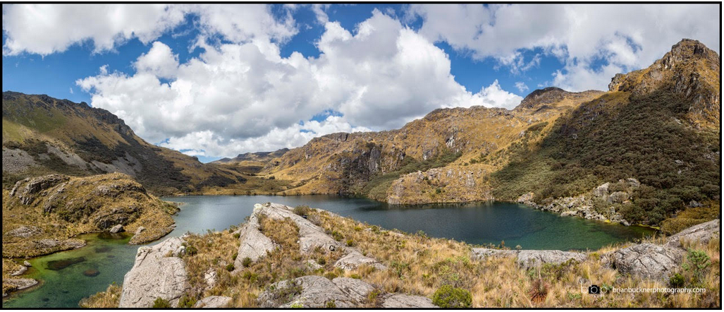
The exposition was a great success as was the catalog presentation of my art several months later. My team from the city was fantastic in every respect. I am deeply indebted to them for their professionalism in the showing and support of my art. I’ll be writing about those 9 photographs and sharing both stories and art with you. They are simply referred to as the “Momento Decisivo Collection.” Look for these to be among my normal column submissions. I’ll note the works that are in this collection as I share them. The name of this photograph is, “Laguna Esmeraldas de las Cajas.” The stories name is, “Solo Crossing the Cajas.” I hope you enjoy both.
Solo Crossing the Cajas
The map wasn’t lying and I knew it. I’d hiked in there before to confirm parts of what was shown on my digital screen. They all checked out. There were scant few routes to get across the wet, spongy tundra and it was coming toward the end of the drier season. Soon, there would be no more chances. I knew I could do it but I felt oddly uneasy about setting out. Sometimes getting started on an adventure is the hardest part of the trip, I reminded myself, as I jammed a water purifier into my Osprey airspeed pack.
I had spent the night before reviewing close up screens from Google Earth. I carefully plotted my route, considering elevation gains and various impasses presented by water and in other places steep, rocky cliffs. I would not have to climb as most think of it with ropes and carabiners. It wasn’t a technical ascent but more about endurance and being able to do what climbers call “scrambling.” At first I had considered going straight through with speed and completing the passing inside of a day. But the problem with these places is that sometimes you have to try more than one route to get to the next waypoint in your hike. I knew that the chance of personal injury was the most dangerous part of my planned adventure and I used that to temper my thoughts concerning how to approach the crossing through the mountain passes.
Cajas National Park is a protected area, set aside high in the sierra of the Andes Mountain range. The going is steep and rocky with lots of tundra. The entire area is sprinkled with beautiful lagoons created by glacial activity during past ice ages. I had noticed on a digital map there seemed a way to cross the entire area at what appeared to be its narrowest point. There were some steep places in there but it looked doable for me. I wanted those photographs. That’s always a driving factor because there’s only one way to record those beautiful places. As you may have heard, you have to go to know.
The mixto driver couldn’t decide whether I was an especially crazy Gringo or maybe Indiana Jones. My eyes pierced him from behind my RayBans as I assured him that my disposition lay somewhere between the two. As directed, he had taken me just past one point of the Continental Divide and into the edge of a valley. I signaled him to stop close to a place I had parked El Fantasma on previous recon trips. He sat there a long time watching me begin my trek up through some rocks and then onto a sloped plateau, bisected by a rocky stream, before he pulled away in the beat up green and white pick-up.
I had a 35 liter day pack and a very small camera bag along with my trekking poles. I had some light plastic in case of rain but I had decided to keep it very trim. No tent for me. I had some chocolate, a tiny water purifier and a ziplock with steak and potatoes in it. I had a little fruit and some jerky I had made. My rain gear was with me as were a small kit with sutures and elastic braces for sprains. Yeah, I really do think I can stitch myself up if I have to.
The first photograph I made is the panorama shown here today. It was recorded as five different photographs which I later joined together in the digital darkroom to create the extreme wide angle view. This was about three miles in on my crossing. After the shots, I circled around on the left side of the photograph where you can see the scree on the steep slope. The right side was impassable due to vertical, craggy cliffs. At the end of the lake in the picture is another small lake, there was little water in it as it had been dry for two months. Above there and again to the left, I spent the night after crossing the highest point for my trek; somewhere around 13,200’ and 13,600’.
I used part of my plastic as a ground cover by pushing it under a long low boulder on the edge of a slope. There was enough room there to make a flat and sheltered spot. I piled up a few rocks on the outer edge of my overnight home in case I might slip from my safe spot and take a tumble. After all, I might have nightmares about the Woowoo! I had once read an article in Cuenca High Life that said they frequented the area. Cold steak and potatoes with a whole Ritter Alpenmelk bar was as divine a dinner as I had had in some time.
It had become cloudy obscuring the milky way so on to bed, or rock, I went. I thought of the Woowoo again. I could tell I was smiling to myself. I felt very happy and complete in the moment. Yes, alone, in the middle of the high sierra there is great peace. I slipped into my dreams.
My phone’s battery was not too good and it was dead by morning. I had no watch but I could tell it was about 5:00 when I woke up. The clouds had receded and every lantern in the heavens was ablaze. The tiny dots mixed together into a glowing blanket of purple and green light; I was speechless before the sight. I used my tiny but powerful LED headlamp to help me straighten up my little bed of rocks and to clean up any evidence that I had ever passed that way. It’s the scout in me that always reminds that I should only leave my footprints behind.
It was boggy and steep in the various slopes I followed down, down, down that morning. My boots got wet but only the left foot actually submerged in a boggy area. I was tired and there was still a ways to go. I could see the dirt road below me that would eventually connect to Ordonez Lasso or the main Caja’s access road. I finally got there in the afternoon after taking several breaks. It was a good ways from there to the main road and I had seen no vehicles traversing the slopes from above. Lucky for me, I was only on the dirt for ten minutes or so before a family picked me up in their hauler. It took longer than I thought it would to get down to the main highway.
Another mixto was passing as we reached the bottom of our descent. The driver of the hauler honked and signaled and the mixto driver hit the brakes. Safe in the mixto, I paid the driver to use his phone giving Edie a quick call to let her know my solo crossing of the Caja’s had ended on a successful note. 35 minutes later, I was at my home in San Joaquin, Ecuador and in the arms of my beautiful wife. On the table sat my pack and camera bag. In that camera bag was a compact flash card and on it, the digital record of my adventure, crossing the Cajas National Park through the rocky mountain passes. Even though I made other interesting photographs during my solo crossing, the panorama shown here was the best. Now, I’m thinking about crossing the Caja’s at their widest point. That might take two chocolate bars and two memory cards, I’ll just have to see.


