


Study shows tsunamis could be catastrophic along South America’s — and Ecuador’s — coast
By Brian Heggston
A study by the Seismic Risk Center at the University of Chile reported that large portions of the South American Pacific coast are susceptible to massive tsunamis capable of destroying coastal communities and killing thousands. In Ecuador, the study identified several areas that have suffered large tsunamis in the past and are likely to in the future.

The aftermath of a 2018 tsunami in Indonesia.
The study conducted more than 200 simulations in the most vulnerable areas in Chile, Peru, Ecuador and Colombia and reviewed geologic data beginning 10,000 ago. “Due to the convergence of Nazca and South America geologic plates, the region is one of the most seismically active in the world and human development must take this into consideration in its planning processes,” the study’s report said. “Within any 100-year period, we can expect as many as three tsunamis of up to 25 meters in height. This is the historical norm.”
Among the most catastrophic South American tsunamis in modern history was one that killed an estimated 25,000 following an 8.5 magnitude earthquake off the coast of Arica, Chile in 1868.
Another, following an 8.8 magnitude quake in 1906 killed as many as 4,000 in the Ecuador-Colombia border region and another 200 in Hawaii and Japan. In both cases, the tsunamis reached heights of 25 meters [82 feet].
The study reported that an earthquake with an estimated magnitude of 9.5 off Ecuador’s Santa Elena peninsula in the year 1050 sent a tsunami wave of 60 meters [198 feet] inland for 20 kilometers. The study concluded that if such an event occurred today, more than 100,000 people would be killed and all human-built structures would be destroyed.
Among the organizations participating in the study was the Ecuadorian Navy’s Oceanographic Institute, which conducted research on the off-shore subduction zone.
In its conclusions, the Seismic Risk Center pointed out that tsunami risk varies greatly based on coastal geologic conditions as well as off-shore conditions on the ocean floor. “In general, bays and inlets are most at danger because of the potential for accumulation of water,” the study reported.
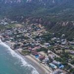
In Ecuador, the study said that the most vulnerable part of the coastline is from Manta north to the Colombian border, where earthquakes like the 7.9 event in 2016 are most frequent. It added, however, that “based on historic and pre-historic events, no area of the South American coast is safe from large earthquakes and tsunamis,” pointing to the Santa Elena tsunami as an example.
According to researchers, the results of the study will be used to update seismic risk maps for Chile, Peru, Ecuador and Colombia and provide guidance to local governments for developing risk management strategies.
_______________
Brian Heggston is a research fellow at the University of Miami Oceanographic Studies Center.